A very bright bolide passed over eastern Germany on Friday night, May 12, shortly after 23:15 CEST. Despite the cloudy skies over most of the Czech Republic, it was observed and reported by a larger number of casual witnesses. However, the weather was considerably better in the northern half of Germany as well as in Poland, so especially there this fireball attracted much more attention (entry in the IMO fireball database https://fireball.imo.net/members/imo_view/event/2023/2561 ).
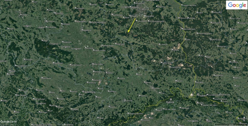
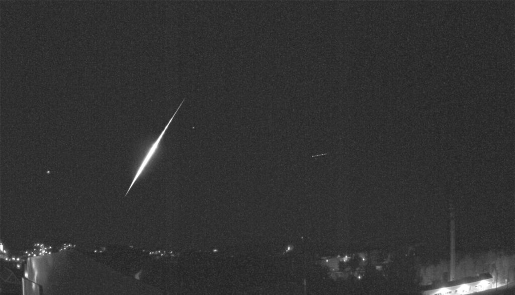
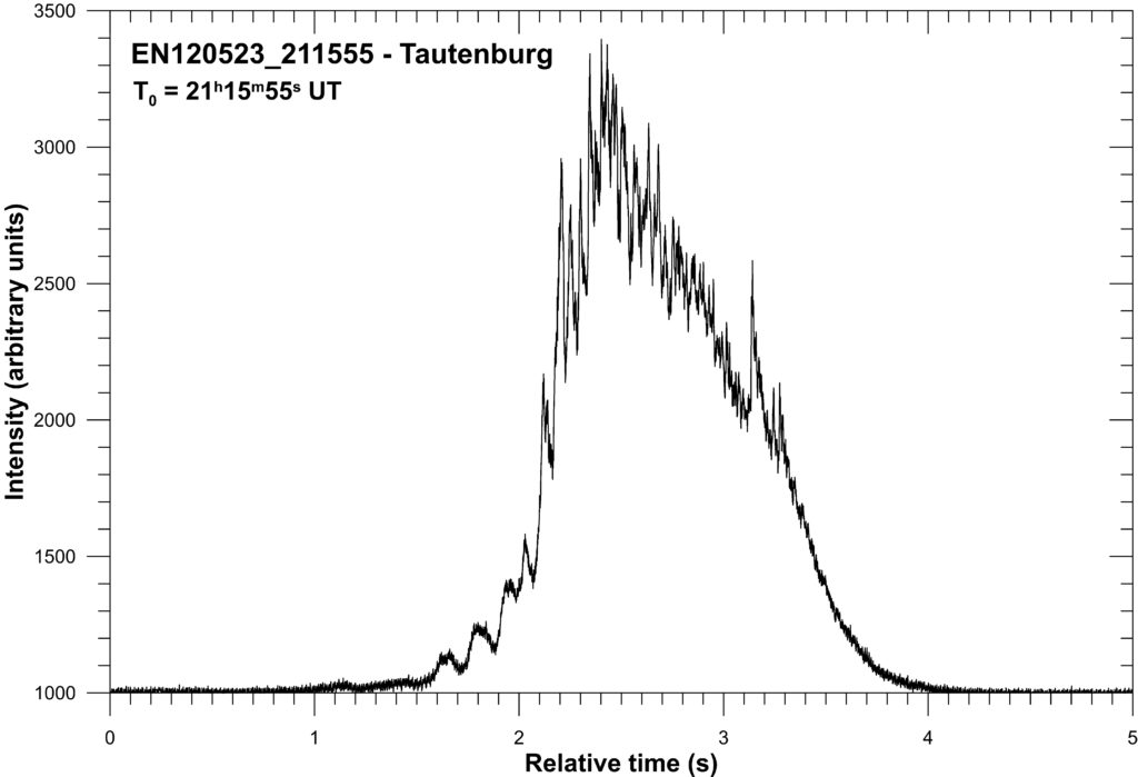
It turned out that three stations in the north-western part of our network, i.e. closest to the bolide’s path (see Figure 1, the bolide is marked with a yellow arrow), were at least partially clear and so we have the most important records from there. These are the Czech stations Frýdlant in Bohemia, Jičín (at both stations the bolide was recorded by both photographic and video cameras – the sum image from the IP camera from Frýdlant is in figure 2) and also Tautenburg in Germany (Thuringia), from here we have, besides the zero order, the photographic spectrum and also the strongest radiometric record – see figure 3. Thanks to all these records, it has been possible to describe in detail and reliably both the atmospheric trajectory of the bolide and its orbit in the Solar System, and even the composition and structure of the original body (meteoroid). It is also possible that a very small fraction of the original mass of the body may have survived the passage through the atmosphere and landed on the Earth’s surface, but a systematic search in this case makes no sense because both the number and mass of the fragments are very small. Therefore, we have not determined a possible impact area at this time.
So what did exactly happen on the night of 12-13 May 2023 south of Berlin?
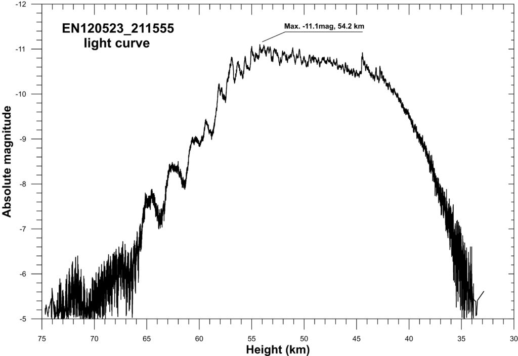
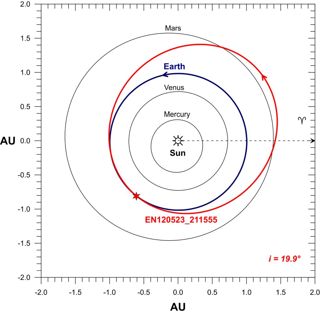
At exactly 23 hours 15 minutes and 55 seconds CEST, a meteoroid weighing approximately 12 kilograms entered the Earth’s atmosphere and was first detected at an altitude of 88.8 km just less than 25 km SSW of the centre of Berlin. The body was moving at that time at a relatively low speed of 15.8 km/s and continued its flight in an approximately SSW direction along a relatively steep path inclined at an angle of 61.6° to the horizontal. The bolide reached its maximum brightness of -11.1 magnitude, slightly less than the brightness of the full Moon, in a flare at 54.2 km above the Earth (see Figure 4). From an altitude of 40 km, the meteoroid began to fragment more significantly and finally disappeared at an altitude of 28.5 km above the ground. The bolide flew the entire 68.6 km long light trajectory in 5.1 seconds. Its projection onto the Earth’s surface is shown in more detail in Figure 5. Prior to its collision with Earth, this meteoroid, about 20 cm in diameter, orbited the Sun in a low eccentric and only slightly inclined orbit, coming very little closer to the Sun than the Earth and not far behind the orbit of Mars in the inner part of the main asteroid belt – see Figure 6. It is very likely that it was originally a small fragment of an asteroid from the inner part of the main asteroid belt.

Author:
Pavel Spurný
Department of Interplanetary Matter
Astronomical Institute of the Czech Academy of Sciences (CAS)
Fričova 298
251 65 Ondřejov (Czech Republic)
email: mph@asu.cas.cz
Images and data are not intended for further dissemination and publishing. Rather, please refer to this translation, the original page (https://www.asu.cas.cz/~meteor/bolid/2023_05_12/index.html) or contact the author.
Translated with www.DeepL.com/Translator (free version) and edited by Francisco Ocaña

 You saw something bright and fast? Like a huge shooting star? Report it: it may be a fireball.
  You counted meteors last night? Share your results with us!
  You took a photo of a meteor or fireball? You have a screenshot of your cam? Share it with us!
  You caught a meteor or fireball on video? Share your video with us!